GIS Application
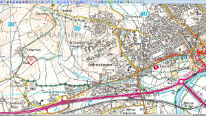
Manage your spatial data through InkGIS a fully flexible Geographic Information System, with no single-seat license restrictions. This application can be run within the HEROS DAM and can be used with an unlimited distribution license granted to the HEROS Development Group, exclusively for using with the HEROS application. The GIS Application will display any mapping data that you are licenced to use.
The main features comprise:
- Integration of raster and vector datasets from a wide range of formats.
- Dynamic linking between data stored in the HEROS DAM and map layers.
- Provides close integration with QGIS, ArcGIS & MapInfo by serving and consuming Web Map Services (WMS) and Web Feature Services (WFS).
- Range of processing functions, vector drawing and manipulation.
- Hyperlink map data to documents, photographs and more.
- Allows integration of HTTP based web map services such as Bing, Google maps, OS OpenSpace and Open Street Map.
- Sophisticated import and export functions, which support GML, KML, GeoJASON, MapInfo MIF and ESRI Shape among others.
- LiDAR and Terrain modelling tool.
- Metadata Management.
