South Gloucestershire Historic Environment Record
South Gloucestershire Council adopted HEROS as their Historic Environment Record system in 2013 and since then it has become an integral part of how we maintain historic environment data and how we use that information in planning decisions, conservation, academic study, private and community heritage and archaeology projects and for local people to learn more about and help shape the places they live in.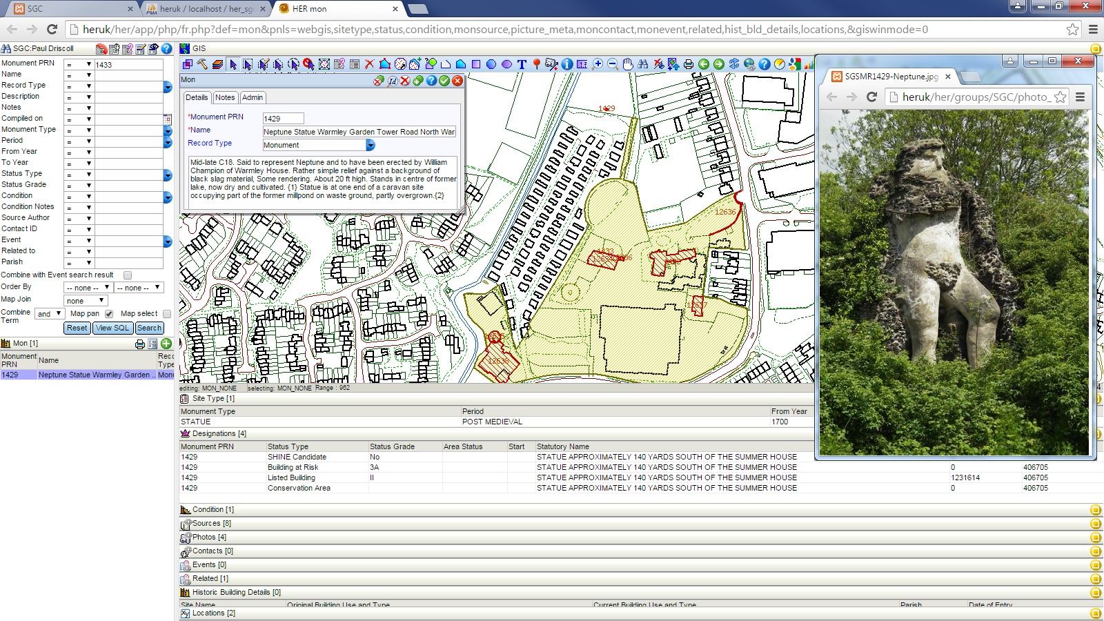
South Gloucestershire Council uses HEROS to maintain information on archaeological sites, buildings, landscapes, conservation areas, battlefields, parks and gardens, commons and greens, pre-1881 settlements, historic landscape characterisation, scheduled monuments, ancient flood land, investigative events (e.g. excavations, conservation programmes etc) and Portable Antiquities Scheme data.
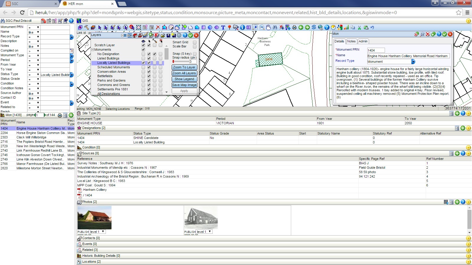
Historic Buildings: South Gloucestershire Council maintains a record of designated (listed) and non-designated buildings that have local significance (locally listed). In the past information on these buildings, such as photographs, survey forms and descriptions, were held in many separate files and databases, but with HEROS we managed to bring this information into one location, through a dedicated Historic Buildings module, which allows us to record details about architectural features and the history of the building. We will shortly be using this information to embark on a review of our locally listed buildings.
In addition, HEROS now connects to the National Heritage List for England, so that changes to national designated assets can be seen through the HER.
WMTS
Whereas WMS (Web Map Service) and WFS (Web Feature Service) were previously available in HEROS, South Gloucestershire Council recently upgraded this to include WMTS (Web Map Tile Service). This has enabled us to connect to really useful datasets, such as the Know Your Place project which is making historic maps such as the original OS and Tithe maps available online. This service can be viewed in HEROS and in conjunction with existing heritage data held in the HER.
Other datasets available as WMS, WFS or WMTS are used in the HER to enhance and enrich our understanding of the past.
Oracle
As part of the transition, HEROS was adapted to work with Oracle, South Gloucestershire Council’s corporate spatial database. HEROS now exists as a database within Oracle.
This has many benefits. Firstly, it complies with the local authority’s requirements for hosting data and making it secure. Secondly, HEROS can access other Oracle datasets maintained by the council such as ancient woodland or planning applications, through its Oracle Connect function. This also works the other way with information from HEROS accessible in other council run systems, such as the planning system, so planning officers can see updated HER records when considering planning applications.
As there is no front end software needed, any council employee can be given access to the HER through a web browser. This means that the HER is no longer a standalone application used by only a few, but a proper integrated system within the council.
Forthcoming modules and developments
South Gloucestershire Council are currently working on a number of modules:
- Historic Landscape Characterisation: This module will provide a way of integrating HLC data into the HER and making it more accessible. HLC contains information on past landscapes, such as whether land used to be part of open medieval field systems, was enclosed by act of parliament or whether it was heathland. Such information is useful in understanding the evolution of a particular place.
- Portable Antiquities Scheme: South Gloucestershire Council use PAS data to enhance our understanding of an area. Currently we are developing a module to integrate this data as part of a regular download from the PAS.